Use the location dashboard
Last updated May 4th, 2026
The Location dashboard lets you track the geographical location and mobile signal strength of your enterprise mobile devices in real-time. To launch the dashboard, select Location from the left navigation pane.
Location data will not appear on the dashboard until you’ve enabled the Location tracking settings and your users have granted Location permissions.
Device status
At the top of the Location dashboard, you’ll find a grid that lets you view all location-related statuses for your device fleet.
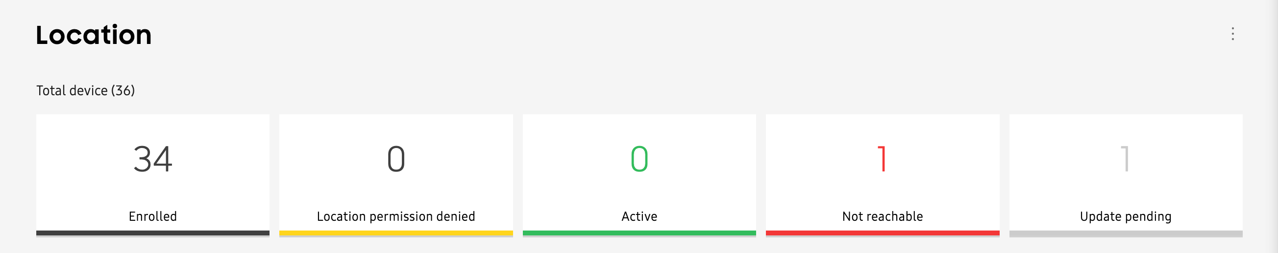
The following statuses are displayed:
- Enrolled: The device is enrolled, but location data is unavailable.
- Location permission denied: The user has denied location tracking permission on their device.
- Active: The device is returning its outdoor location information and is reachable.
- Not reachable: The device’s location was not returned after 24 hours, or the location request was unsuccessful.
- Update pending: A manual location request was initiated, and Knox Asset Intelligence is currently attempting to retrieve the device’s location. If there is no response after an hour, a device is added to the Not reachable status count.
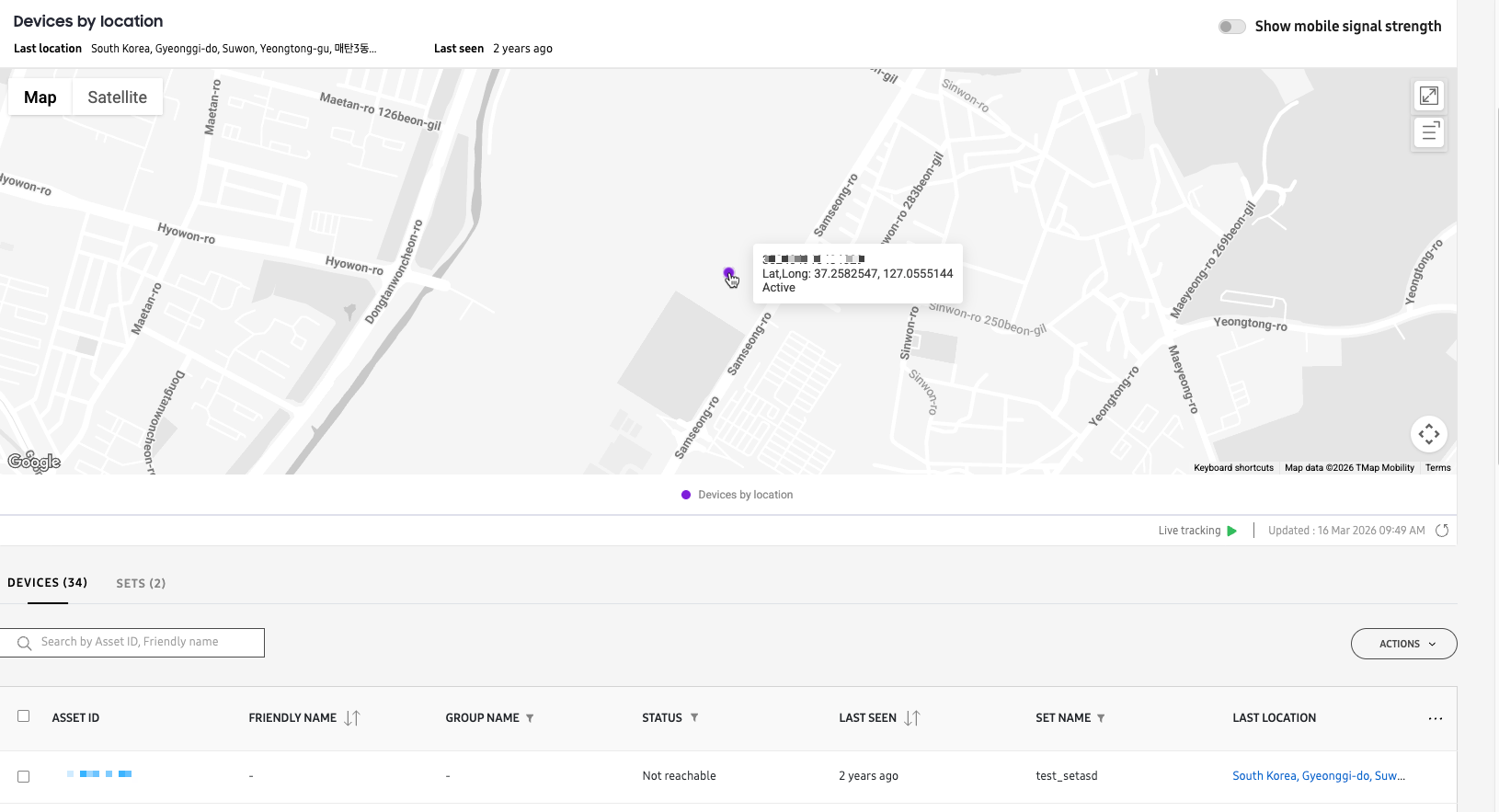
Location map
The map displays your device groupings (represented by gray circles on the map) as soon as you open the Location dashboard. When you zoom in, the circles update to show the device distribution across a given area.

The map features the following:
| Reference | Feature | Description |
|---|---|---|
| A | Map view type | The type of map displayed, whether Map or Satellite. By default, the map opens in satellite view. |
| B | Expanded map view | Lets you view a full screen version of the map. Once expanded, click the button again to return to the default map view. |
| C | Devices list | Lets you see the IDs of every device currently in view on the map. The number of devices shown will correspond with the number of devices in the bubble, and may vary depending on the current map zoom level. |
| D | Search and filter |
Click the Search icon and enter a device IMEI number to locate it on the map. If the device is sending location data, you'll see its last known location represented by a dot. Click X in the search field to clear your results and return to the default map view. Click the Filter icon to locate devices that report a specific status or mobile signal strength. Select your filter options, then click APPLY FILTERS to view only those devices on the map. To remove your filters, click the Filter icon once again, then click CLEAR. |
| E | Live tracking |
Click to receive continuous location updates from your devices for up to 30 seconds at a time. Live tracking stops after 30 seconds, after which you'll have to click the Live tracking button once again to receive continuous updates for another 30 seconds. This button can only be clicked after a certain zoom level. If you can't click the button, try zooming in on the map until you can. If your devices are active and reporting location data, you'll see a dot on the map showing the device's location. As the device moves, the dot on the map also moves. |
| F | Mobile signal strength |
Lets you identify when devices are situated in areas with weak cellular coverage or potential dead zones. To use this feature, you must first enable Mobile signal strength with location. On the map, you'll see the mobile signal strength status of every device in your fleet represented by colored dots. These dots are updated at the same rate as your location data collection frequency.
These dots also appear in the map's Device list, letting you quickly correlate the device IDs with each mobile signal strength status. If you want to only show devices with a specific status—for example, only show Bad devices—you can select the status using the map's Filter options next to the Search icon. |
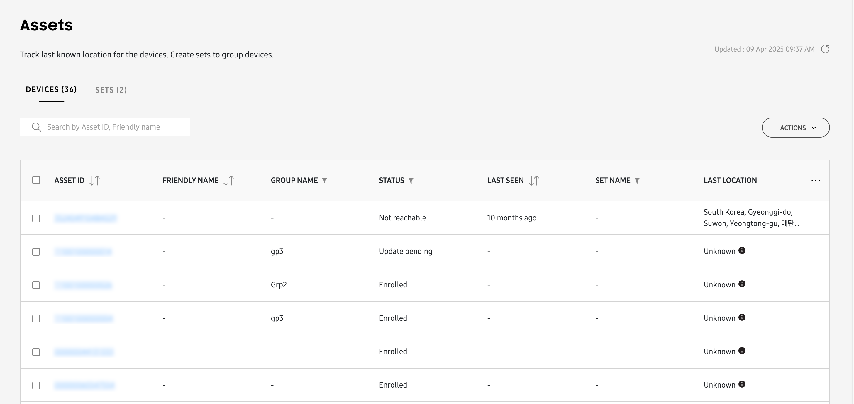
Manage assets
The Assets table below the map lets you quickly see the location status and last known update times for all of your enrolled devices. This table consists of two tabs:
- Devices — Your mobile devices (smartphones and tablets). See the Location Overview page for a full list of devices that support location tracking features.
- Sets — Your location-tracking devices organized into logical collections.
Upload assets
The Devices in the Assets table are uploaded through the normal device upload process documented on the Manage devices page.
Sets
Sets are logical collections of devices that exist only within the Location dashboard. They function similarly to device groups, but with the following differences:
- Sets can be created on the console, whereas Groups can only be created by uploading a CSV file or through an EMM.
- The same device can exist in several Sets, whereas a device can only exist in one Group.
A default set (S.0) containing all (location enabled) devices is automatically created. This default set can’t be deleted. You can create additional Sets based on your requirements.
To create a set:
- On the Assets page, click the SETS tab, then click NEW SET. The Add devices to new set page opens.
- Select one or more devices from the list, then click ADD. You can also use the search bar to find devices before adding.
- In the Create new set dialogue, give your set a name and optional description, then click ADD. The name can only contain alphabetic, number, dash, or period characters, and cannot be more than 18 characters in length.
- Navigate back to the SETS tab to view a list of all sets in your fleet.
To edit set information:
- Click a SET ID from the list. A side-panel displays your set information.
- Click Edit to change your set name, use the toggle to make the set Active or Inactive, or click DELETE SET to remove it entirely.
To add or remove devices in a set:
- Select a set from the list, then click the ACTIONS > Add devices to set or Remove devices from set.
- On the following page, select the devices from the list, then click ADD or REMOVE.
To delete a set:
- Select one or more sets from the list, then click the ACTIONS > Delete set(s).
- On the following window, click CONFIRM.
To download your sets information as a CSV file, select one or more sets from the list, then click the ACTIONS > Download CSV.
View asset information
Viewing asset information from the Location dashboard is similar to viewing device information from the Devices page. Simply select an ASSET ID to view the asset details in a side panel.
If you have many assets in your list, you can quickly find an asset by entering its IMEI or serial number in the search field.
Last location
If a device is reporting location data, you’ll see an address link appear in the LAST LOCATION column of the Assets table. You can click the link to zoom to that device’s last known location, where you’ll see a purple dot appear on the map. Hover over the dot to see the device’s coordinates and current device status.
Find an asset
The Assets table provides several tools to help find devices in the real world more easily. With these tools, you can force the device to play a sound, vibrate, or turn on its flashlight for a set duration, and send notifications to device users with instructions to contact the company in the event the device is found.
To find an asset:
-
In the Assets table, use the checkboxes to select one or more devices, then click ACTIONS > Find asset.
-
In the Sound field, set the alert volume level by moving the slider.
-
In the Vibrate field, toggle whether you want to force the device to vibrate (Default: Off ).
-
In the Flash light field, toggle whether you want to turn on the camera’s flashlight (Default: Off ).
-
In Battery saving mode, toggle on if you want to place the device in battery saving mode when an alert is sent (Default: Off ).
-
In Set time period for the triggers, select the duration that you want to trigger the alert for:
- Until the device is found: activates the alert until the device user responds to it.
- Set duration (Default: 30 minutes): Determines the amount of time that the alert is active.
-
In SUPPORT CONTACT DETAILS, enter the name of your organization and a contact phone number. The users will see a notification asking them to call this number if the device is found.
-
Click FIND NOW to send the alert and notification to the selected devices.
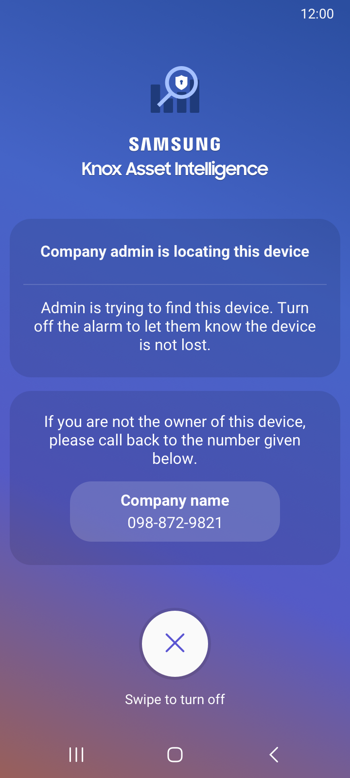
Find asset user screen
After you click FIND NOW, the user sees a full screen notification on the device asking them to swipe to turn off the alarm. Doing so lets you know that the asset isn’t lost, and is still in use. In case the user misses the alert, a message appears in the notification panel that instructs them to contact you about their device.
If the device is lost and you’ve filled in your organization’s contact info, a button appears underneath the alarm with a contact number. The user can tap the button to call the number on the screen.
Get the latest location
If you want to get the last known location for a device without having to wait for its next update interval, you can use the Get the latest location feature. To do this:
-
On the Assets page, use the checkboxes to select one or more devices, then click ACTIONS > Get the latest location.
-
The Assets page will update and you will see:
- Update pending in the STATUS column for your queried device(s) if they are not active.
- An updated date & time in the LAST SEEN column and location information in the LAST LOCATION if they do respond.
On this page
Is this page helpful?